Off the beaten path, Colorado's Unaweep Tabeguache byway weaves its way through some of the wildest lands in America.
Off the beaten path, Colorado's Unaweep Tabeguache byway weaves its way through some of the wildest lands in America.
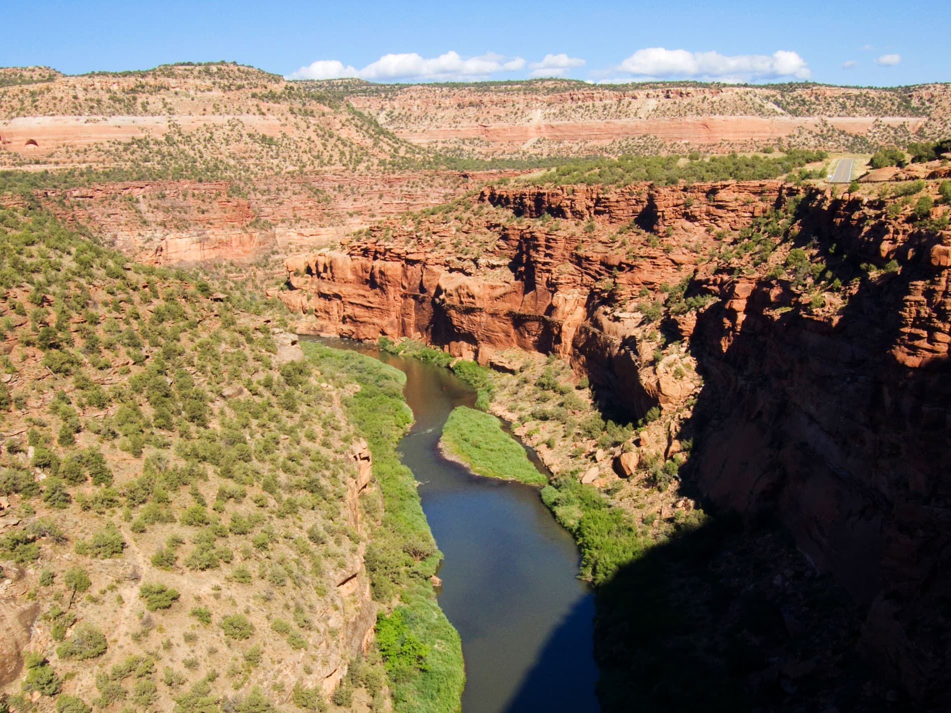
The Dolores River Canyon is an obvious highlight, with its smooth sandstone walls and winding river.
This southwestern-Colorado drive cuts through a canyon for most of the way as it follows the Dolores and San Miguel rivers. Over the years, these water sources slowly ate away at the soft sandstone, creating the rugged flat-top canyon enjoyed now for its vast vertical walls and cliffs.
Historical signage along the byway retells the journey of Dominguez and Escalante, two Spanish friars who traveled through the region in search of a passageway from the missions in New Mexico to those in California.
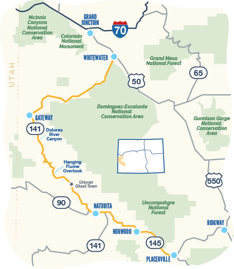
Start your drive in Whitewater, a rural community located just southeast of Grand Junction on U.S. Highway 50. Be on the lookout for desert bighorn sheep — your best bet to spot them is on the rocky ledges and grassy knolls along the first few miles of the byway.
Just under 30 minutes from Whitewater on Highway 141, Unaweep Canyon is a hidden gem worth savoring as its own daytrip. It cuts across the Uncompahgre Plateau and means “the canyon with two mouths” as two creeks flow out of it in opposite directions. Unaweep’s jutting, granite walls make it a climbing paradise and a scenic location for hiking, mountain biking and camping spring through fall. As you drive, keep your eyes peeled for Driggs Mansion, the ruins of a one-story sandstone house built in 1918.
Farther down the byway is rugged and remote Gateway, a town near John Brown and Unaweep canyons. It offers access to untouched backcountry exploration in the La Sal Mountains and Uncompahgre National Forest. Gateway is additionally home to Gateway Canyons Resort — a beautiful high-desert retreat offering access to mountain biking, horseback riding, hiking, climbing, fishing, rafting and more. Classic-car aficionados should make a stop at Gateway Auto Museum, which features more than a century of automotive history, including vehicles from the Hendricks Collection (privately owned by Discovery Channel founder John Hendricks, the visionary behind the resort).
From Gateway, head 30 miles south to marvel at remnants of the area’s rich gold-mining history. The skeletal remains of Hanging Flume — an aqueduct system completed in 1891 to carry water for the mining process — can be seen clinging to the side of a sheer cliff. You can view this 19th-century ruin from an overlook just off the byway.
Your next destination is Uravan ghost town, hidden in the southwest corner of Colorado between Naturita and Gateway. Believe it or not, this section of highway played an integral role in World War II. The uranium used in the country's first atomic bombs was mined near Uravan, the midway point of the route. But there's more history here than just the A-bomb. Precambrian dinosaur and amphibian fossils have been found within the striated, red-sandstone canyon walls that surround the road. This area's soil even produced rich copper reserves for entrepreneurial miners.
Beyond Uravan is Naturita, a small mining town with lots of history. In the late 19th and early 20th century, copper and uranium mining reigned supreme along this byway. Today, you’ll find a community surrounded by Bureau of Land Management land and the Uncompahgre National Forest, making it ideal for wildlife watching. In addition, its proximity to the Dolores River makes it a popular spot for fishing and rafting.
Drive on to Norwood, which sits atop Wright’s Mesa at an elevation of 7,000 feet. Here you can stretch your legs and marvel at the views of gaping desert canyons, as well as the San Juan and La Sal mountain ranges. The city’s rustic setting also makes it a hot spot for everything outdoorsy, from climbing and foraging to horseback riding and paddling.
End your journey at Placerville, a former mining camp found along the San Miguel River; it’s a rest stop for hikers and fishers, as well as travelers heading to Ridgway and Telluride.
Events on the calendar: West End 4x4 Jeep Tour in Naturita, San Miguel Basin Fair and Rodeo in Norwood, Ridgway RiverFest


Before you go, spend a day exploring Colorado’s Grand Valley — Grand Junction and Palisade — featuring wineries, distilleries and miles of trails.

A quick drive from Naturita, this remote and sparsely populated basin offers red-rock formations, camping and rock climbing.

A basecamp for exploration throughout the San Juan Mountains, this tiny alpine town is home to a creative district and numerous artists.

Just 5 miles from Naturita is Nucla, where you'll find biking trails, an entrance to the Uncompaghre National Forest, and off-roading adventures on the Rimrocker Trail.